October 31, 2015

Serious Weather

During major weather events like this, everything seems to happen at once.  Consider the Saturday AM National Service warming map for our region (see below).   We have flood warnings, gale warnings, flood watches, winter storm watch (snow), small craft advisories, and more!


The rain totals over the last 24 hr (ending 7AM Saturday) have been substantial, with some mountain locations getting over 4 inches (see map below which shows locations that received over 1.5 inches)

Yesterday afternoon an extraordinary Puget Sound Convergence Zone set up around Everett (see radar image below fro 1:13 PM), with intense rain brings .5 to 1.2 inches in an hour to some locations in the lowlands.  As described in previous blogs, the Puget Sound CZ is the result of air converging on the leeside of the Olympics.


A number of major western WA rivers are surging now towards flood stage, as illustrated by the Snoqualmie near Carnation (below).  And water worries for Seattle are rapidly disappearing as the Chester Morse and Tolt reservoirs go into rapid refill mode.


And there were strong winds with this event (see map of wind gusts over the past 24 h).  Note particularly strong westerly winds on the eastern slopes of the Cascades as the flow accelerated down the lee slopes of the Cascades.   Winds were gusting to 60-80 mph on exposed peaks in the Cascades.


The next surge of rain is moving in now, something well illustrated by the latest (7:15 AM) radar image

There is plenty for precipitation to come, as shown by the UW WRF forecast for the 72h period starting 5 AM this morning.   You will notice the huge contrasts between the rain shadow region east of the Olympics, mountains of Vancouver Is, and Cascades and the windward sides of the barriers.

And there will be be the high-country snow....but that will be tomorrow's story....

October 30, 2015

Serious Precipitation and Flooding is Probable During the Next 72 Hours

9 AM Update

Here is the 24 hr precipitation ending 8 AM Friday for sites with more than .5 inch.  Some locations on the western slopes of the Cascades and Olympics have already gotten two inches.


The precipitation over the same period from Seattle RainWatch (based on calibrated radar data) shows a profound rainshadow NE of the Olympics, but 1.5-2 inches along the western Cascade slopes.
________________________________________________

It is now clear that we are going to have one of the wettest periods in a while starting today, with less rain in the lowlands and much more in the mountains.

An infrared satellite photo late Thursday, shows the moisture arching into our region


Let me show you a sequence of 24h precipitation totals from the UW WRF modeling system.  For the period through 5 PM Friday there is 1-3 inches in the mountains.  Note that Puget Sound region is drier--the is due rainshadowing to the east of the Olympics Mountains, something expected from the westerly flow regime we will be in.


Far more serious the next 24 h, with some locations in the southern Cascades seeing 5-10 inches

 For Sunday, there is still plenty of moisture, but the focus moves southward.


Adding up the entire period is impressive and scary (see below), with 5-10 inches over much of the WA Cascades and mountains of southwest WA, with some peaks getting even more.


This will be enough water to push some westside rivers, and particularly those near and south of Mt. Rainier, to flood stage.  The NW River Forecast Center is predicted a number of local rivers to hit flood stage, with some attaining a moderate flood.


The hydrograph plot for the Snoqualmie River near Carnation shows the story with an extraordinary rapid rise predicted.


The snow forecast for the period is on track, with the amounts being enhanced from the previous forecast cycle (see below).

Need more weather fun?...no problem.   Strong winds will be found along the coast, NW Washington, and on exposed mountain peaks.

October 28, 2015

Finally! Significant Snowfall and Heavy Precipitation in Northwest Mountains

We have waited a long time for this and finally it is close at hand:  significant mountain precipitation and snowfall over the Pacific Northwest.

To warm up, let me show you the forecast of 72-h accumulated snowfall ending 5 AM Monday. Several feet in the Rockies and in the higher elevations of the BC Cascades. The WA North Cascades could get as much of a foot, with modest snow along the Cascade ridge into Oregon.


But most of the precipitation will be rain, so here is the total precipitation for the same 72-h period.  The Washington Cascades gets hammered, with extensive areas on the windward side of the barrier getting 5-10 inches.  Even eastern Washington will get soaked with an inch or two.  Water-refill season will begin in earnest with this event.


This will actually be a two-step event.  During the first part, strong, moist westerly flow will develop over the eastern Pacific between high pressure off California and a trough over the Gulf of Alaska (see upper level map for Friday at 8 PM).

The forecast for 2 AM Saturday morning of atmospheric water vapor, shows a tongue of high values extending towards our region....this is an atmospheric river.


With moist, strong westerly flow hitting and ascending our mountains,  large upslope precipitation will occur.  This event will be significant enough that some local rivers will raise rapidly, some to just below flood stage (see example for the Snoqualmie River).


On Sunday stage 2 will begin, as a strong upper level trough approaches our region.  By that time, temperatures will cool, and with the upward motion associated with the trough, moderate to heavy snow will fall at higher elevations of our mountains.  A tease for our skier friends.


After the trough moves through the Northwest, it pushes into California and a huge ridge of high pressure builds over the eastern Pacific (see upper level map for 5 AM Wednesday).  The Northwest will dry out, but California will receive some welcome moisture.


October 26, 2015

Global Warming: Why are Environmentalists Failing and What Mankind Can Do About It

The biggest environmental issue of our day is not global warming but sustainability:  how can the human species reach a long-term, sustainable relationship with our planet?    Sustainability is controlled by population, use of resources, the climate of the planet, water resources, and much more.

But clearly, global warming is a very serious part of sustainability, with our best science indicating that the planet will warm substantially during the next century as a result of increasing greenhouse gases like CO2.  The environmental community and its allies in the political realm have made global warming their number-one environmental priority.

But clearly the environmental community and the world in general are failing to to deal with global warming.   A fresh approach is needed.

Proof of Failure

The most profound proof is the observed trend in atmospheric CO2  (see below).  It is not only rising, but the rate of increase has accelerated, even with all the efforts on renewable energy, energy efficiency, and the like.   This is failure.
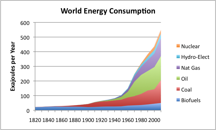
Driven by increasing population and improving living standards in second/third world countries, the demand for energy is surging, with most of it coming from fossil fuels.  Renewables are only providing a sliver of current energy demand, and that will not change soon.


Carbon emissions have flattened in the U.S. and Europe, but rising exponentially in China and very quickly in India.  Countries like China and India want to raise the living standards of their citizens and that requires energy, and those of us in the developed world are in no moral position to ask them to refrain from doing so.  In fact, rising living standards are crucial tools for population control.


Perhaps the most concentrated source of non-carbon energy is nuclear power, but unfortunately, due to the Fukashima disaster and other issues, nuclear power generation is now declining or taken off the table by several nations, just when needed the most to reduce greenhouse gas concentrations (see graphic).
Renewables  (e.g., solar and wind) are growing rapidly, but from a small base (see below).  There is no realistic plan at this point for having them take over the bulk of world energy demands during the next few decades.  In fact, the U.S. government estimates that renewables might reach about 15% of total world energy consumption in 2040.  Not enough to make a real difference.

To seriously reduce the warming effects of greenhouse gases, there needs to be a huge decrease in carbon fuel usage around the world.   Estimates by the international IPCC group suggests that to keep the temperature increase to less than 2C by the end of the century, the concentration of CO2 must remain below 450 ppm (parts per million).  Considering that current CO2 concentrations are now 400 ppm, there would have to be a large reduction from current emission levels immediately.    There is virtually no chance that is going to happen.

But it is even worse than that. Environmentalists have not convinced the general population of the seriousness of the problem.   For example, a recent Gallup poll found that global warming is not even on the top twenty list of concerns of the U.S. population.

And if you ask Americans what environmental problems worry them, global warming is at the bottom of a list of concerns.   They are more worried about rain forests than global warming.


Environmental groups, such as Seattle's Climate Solutions, the National Wildlife Federation, and their media friends, have tried hyping and exaggerating extreme weather events, suggesting that they are at least partly the result of human greenhouse gas emissions.    The more desperate such groups get to ensure folks "do the right thing", the more they rev up the hype machine.   But as the polling numbers above demonstrate, the scare tactics have not worked.  Rather, the obvious exaggeration has undercut environmentalist's credibility.  Some environmental groups like to say that the whole problem is the big, bad oil companies that are using their financial muscle to suppress the truth and ensure inaction.  But that view is simplistic at best--- the lack of action is far deeper and widespread.  It is a societal problem.  And environmentalists have had a huge, but ineffective, megaphone that the oil companies lack:  the media.  Furthermore, a number of environmental groups have undermined their climate message by combining it with fixing other societal problems (racism, economic disparity, etc.).   This is a terrible mistake because it weakens their ability to develop a broad coalition to deal with global warming.


And even more worrisome, the issue has become a political liability, with an entire party (Republicans) dismissing the seriousness of the problem and need for immediate action.  One might argue that Al Gore has done a great disservice by politicizing a previously far more bipartisan issue.

Probably did more harm than good

It is clear that mankind is not willing to forgo the use of economically exploitable fossil fuels.  The search for new sources of oil and gas continue, with the development of new technologies (e.g., fracking) providing huge new sources of gas and oil that society has enthusiastically taken advantage of.  Gas prices are low, encouraging use.

The bottom line of all this is obvious:  mankind is doing very little to stop global warming and there is little hint of any effective action.   And embarrassingly, the uber environmentally aware Puget Sound region, is not doing much to deal with the problem.  Just a few examples:

  • Our fuel-intensive airport is growing rapidly, while our major industry (Boeing) is churning out record numbers of gas-guzzling jets
  • Our roads are choked with cars, our traffic situation is one of the worst in the nation, and our bus system is completely inadequate for the demand.
  • Our politicians are ineffective in this area, preferring to grandstand about environment issues (kayaking out to the Shell drilling platform, pushing short-term rental bikes, flying off to environmental conferences) rather then dealing with transportation, traffic, land use, and energy use in a meaningful way

Some local politicians are ineffective on environmental issues

So is it surprising that our society has been so ineffective about dealing with global warming?   

Few people have thought more about how societies deal with existential threats than Professor Jared Diamond of UCLA, the author of Collapse and Guns, Germs and Steel.   Last year, after giving a lecture at the University of Washington, I asked him:

“Can you think of a single example when a society took economically costly and disruptive steps to avoid a future problem that had not been previously experienced?”

He could not.   Musing, I can offer one example:  Joseph's warning to Pharaoh above 7 drought years.

There have a large number of international meetings to foster agreements on carbon reduction, like Kyoto, Copenhagen, and soon Paris.  But, in general, such gatherings are ineffective and agreed "limits" are often vague and small.

So how do we deal with the global warming problem in a fresh, more effective way?

Global warming can not be considered in isolation from sustainability, population, soil and water resources, and land management.   Population is the key issue.  If there were only 1 billion folks on the planet, we would not be talking about global warming.   But we have many more people, with many nations on or near the edge.   Billions of people in developing  nations want to live a middle class life style like us, but to do so requires energy and resources.  The irony is that the only way to limit population is get folks through the transition to middle-class, as demonstrated in Japan, Korea, the U.S., Australia, and Europe.  So can we get everyone into the middle class without catastrophic global warming?   That is the question.

So how do we deal with global warming forced by greenhouse gases?   I have thought about this a lot.   It seems to me we need a fresh approach:

1.   Since substantial global warming is certain, we must prepare society for inevitable changes.  That means adaptation and making society more resilient.   For Washington State, the probably means more storage of water during the spring, since snowpack will be less.  Getting folks away from rivers that will flood more often.  Fixing the damaged forests of eastern Washington.  

2.  Global warming is a technological problem and technology is our only hope.  New energy sources, better energy storage, ways to remove CO2 from the atmosphere, safe nuclear and new energy technologies that we can't imagine today. But developing these technologies will require substantial investments for research and development on a much larger scale than occurring today.    A few days ago, I learned that someone else has concluded the same thing:  Bill Gates, one the great technologists and philanthropists of our age.   If you want to read his exact words, read his interview in Atlantic Monthly.  Bill Gates gets it.  His advise should be considered seriously.


3.   Society should use cost effective energy-saving and renewable technologies that are cost effective today, like more efficient appliances, high-mileage and electric cars, smart devices, and better insulation in buildings, better mass transportation, and others.  They may not solve the problem, but they will help.

4.  Environmentalists have hurt themselves by being fixated on global warming.   They, and their political allies, should broaden their view to think about sustainability.

5.  Approaches like carbon taxes can be very useful, and we are fortunate to have an initiative (I732) that should be able to secure sufficient signatures for consideration.  

As the old saying goes: insanity is doing the same thing over and over again and expecting different results. When it comes to global warming and greenhouse gases, it is time for a different approach.

October 24, 2015

Hurricane Patricia: Extreme, Poorly Predicted, and Soon to Flood Texas

Hurricane Patricia, which made landfall on the western Mexico coast, has been a jaw-dropping hurricane, with a long-list of superlatives:

The lowest sea level pressure ever observed for a hurricane in the Western hemisphere:  879 hPa (millibars).  The absolute lowest pressure anywhere was 870 hPa in Typhoon Tip in 1979 over the western Pacific.  We are talking about bringing the normal pressure at 5000 ft down to sea level----amazing.


The sustained winds reach 200 mph, with gusts substantially higher  This greatly  exceeds the criteria for a Category 5 storm (sustained winds equal or greater than 156 mph).

The storm developed faster than any other Western Hemisphere storm on record, going from a a tropical disturbance to a category 5 storm in less than 24 h.   We are talking about a 100 hPa pressure decline in less than a day.  Unbelievable.

The eye of Patricia was quite small (about 8 miles) at landfall yesterday, something obvious in the satellite picture shown above.

Why did Patricia rev up so quickly?   I don't think we understand the origins of the extreme behavior, but the conditions were ideal:  very warm ocean temperatures, deep warm water, low wind shear in the vertical, unstable conditions.  In fact, the waters off Mexico are now some of the warmest on the planet (see image) and a big reason for that is the major El Nino that is occurring currently.
Forecast Problems

Patricia is a poster child, perhaps the worst case in a while, of a major problem for meteorologists:  we have gained substantial skill in forecasting hurricane tracks, but we often fail in predicting hurricane intensification.

Let's be honest here: NONE of our numerical prediction models, or our statistical aids, predicted the extreme intensification of Patricia.

Consider the National Weather Service's primo modeling system for hurricane forecasting (HWRF), something they have invested tens of millions in.  Here is the HWRF forecast available late Wednesday. HWRF  forecast (purple lines) lowest pressure only declines to 950 hPa and sustained winds reach 95 knots (109 mph).  Not good--they are predicting a storm that is half as intense as reality.


The forecasts the day before improved substantially--but that left little time for preparation.  Here is the forecast available about 12h prior to landfall.

In contrast to intensification forecasts, the track forecasts were skillful and stable for days before.  Why the difference?   To forecast track one does not have to predict the complex inner dynamics of the hurricane;  if you can skillfully predict the general environment (the steering flow), you can get the track correct.   And our large scale models (like the NOAA GFS and the European model) can generally do that.

But predicting intensity is a very different thing.  You need to know the inner structure of the storm and predict its evolution.   The size and evolution of the changing eyewall clouds, the development and contraction of new eyewalls, and much more.   This is very hard in many ways.   Some research suggests that it may not be even possible to do this more than a day or two out.  An area of active research.

Texas flooding

Patricia, although radically weakened by its passage over land (robbing it of moisture) and terrain (which tears the lower structure apart), is not done causing problem.  The residual circulation and moisture of the storm will meet up with an approaching upper level disturbance over the southwest U.S, and moisture from off the Gulf of Mexico. to produce extreme precipitation over southern Texas.  Here is the predicted precipitation total for the next 48h from the National Weather Service GFS model:  10-15 inches over coastal Texas.   Serious trouble and the potential for flash flooding.


The National Weather Service forecast for Houston says it all:

October 22, 2015

The atmospheric rain switch is about be flipped

It happens nearly every year.  We enjoy a beautiful and generally dry summer--climatologically one of the driest in the nation.

September is usually sunny and mild, with a few rainy periods that aren't too much of a nuisance.

Then, the first part of October brings cooling, but is often quite mild and not that wet.

But then something happens.  The Northwest rain switch is flipped, and sometime in late October or early November we transition to our wettest, windiest weather.


The worst week of the year?  Amazingly, the last week of November.

It is truly remarkable how quickly our region's weather degrades;  almost like going off the proverbial weather cliff.

And folks, if the weather models are correct, it is going to happen in about a week.

But before I tell you about your sodden fate, let's look at climatology, in this case at Seattle Tacoma Airport.  Here is the probability of getting .01 inch in a day.  Very low during the summer, rising to about 40% in early October, but there there is the major ramp up to roughly 65% during the first week of November. From then on into March we are doomed to moisture almost every day.


But that is light rain.   What about the change of getting say, .5 inches, over a week? (see below)  A huge ramp up between mid-October and the first week of November to about 75%.  Ouch.  And we stay up there for a while.


So, after softening you up with climatology, let me show you some precipitaton forecasts from the National Weather Service GFS model.  During the next few days (through Sunday early AM), we will get virtually nothing, as shown by the cumulative rain during that period.   So enjoy your Saturday!

But prepare yourself.  Here is the forecast for the next 360 h (15 days). Orange is over 5 inches...and that is what is forecast over western Oregon and Washington.  Even northern CA gets rain.


 Now this is just one model and one forecast.  What about the forecast from the many-model NAEFS North American ensemble system?  (see below) The second panel is precipitation. The "whisker" shows you the range of precipitation amount for all the models and horizontal bar gives the median amount.  Rain turns on around Oct 28th. The bottom panel shows cloud coverage greatly increases at the same and the panel above that is wind, which also increases.   Rainy, windy, and cloudy.  Sounds like typical Seattle winter weather.


So enjoy the last week of pleasant, mild, perfect fall weather.  Take your last major hike on Saturday. The models don't think it will last, El Nino or not.  During the next two week we should be making the transition to Northwest winter, first with light rain and then the heavier stuff in early November.

Our weather reckoning is coming.  And the switch is about to be flipped.


October 20, 2015

Warm October and Seattle School Board Races

Things have been heating up here in the Northwest, both in the atmosphere and in the election sphere.

First, the atmosphere.  This has been a very warm October so far, particularly for the nighttime minima.

Here are the temperatures for Seattle Tacoma Airport and Yakima for the last four weeks.   Temperatures were near normal at the end of September on both sides of  Cascades, but in early October we switched to a warm pattern, particularly for minimum temperatures.  Blur your eyes a bit...there is really no downward trend for temperature over the past month.
Another way to see the recent warmth is temperature anomaly maps (difference from normal) for the past two weeks.  The ENTIRE western U.S. has been warm, with much of WA state 3-9F about normal.  One of the best mid-October periods I can remember.


Why so warm?  The upper air height anomaly map (difference from normal of the heights/pressures at 500 hPa, about 18,000 ft).  There is a trough offshore (blue colors) and a big ridge (yellow colors) over much of the U.S.

This pattern is quite typical for El Nino years and we have a big one this year.  Precipitation has been near normal over the Northwest, so things are greening up.

We have another 5 days of warm/dry weather and then things change in a big way.  The end of October is often a dramatic step into wet and murk.  The latest model runs indicate the atmospheric switch will be flipped into a different position.  Get ready.


Seattle School Board

Four seats are up for grabs and only one incumbent is running.  Here are my picks for three of the races.

District 6:  Marty McLaren

Rated Very Good by the Municipal League and the only incumbent running, Marty brings a very special combination of experience, even-temper, and judgement to the school board.  She has been a successful warrior for better math in elementary schools, pushing successfully for the non-fuzzy Math In Focus and the dumping of terrible Everyday Math.   She played a major role in securing Dr. Larry Nyland as school superintendent... a home run considering his deep experience and competency.   Marty is able to keep channels to the district administration and know how to maintain respectful and productive relationships.  She has substantial support including outgoing School Board Presidents Sharon Peaslee and Sherry Carr, who know Marty's value on the board, and major political groups like the 46th District Democrats.  With so much turnover on the board, it is critical to keep Marty in place.  And she has big plans, like replacing the poor middle school math program currently used:  Connected Math.


District 3:  Lauren McGuire

Rated Outstanding by the Municipal League.  Lauren has deep experience in Seattle Public Schools on a number of committees and positions.  I met with her over coffee--I came away impressed with her vision for Seattle Public Schools and her broad knowledge of its strengths and weaknesses. She has a math background and understands what is wrong with the Seattle Public School math program and how to fix it.  I talked to her opponent, Jill Geary, about math and it was clear this was not her issue.


District 2: Rick Burke

Rated Very Good by the Municipal League.  I know Rick very well and he is about the most perfect candidate you can imagine for the position.  Three kids in Seattle Schools and highly active on a number of levels.  Rick has been a major leader in the fight for better math education in our area and has a technical background.  He has excellent people skills, works well in groups, is razor smart, and is focused and organized.  He will be a major leader on the board once he is elected.


There have been a lot of school board critics making  a lot inflammatory statements, but the truth is that the district has made major advances during the past few years, with better management, substantial growth in student populations, rapidly rising test scores, and an absence of financial disasters.

There is a reason that students are flocking to Seattle's schools.

Should I Let AI Write My Blogs?

I spend a lot of time thinking about and writing my blogs.   Could AI apps do the work for me?   Could any of you tell the difference? Well,...