3PM: cool, cloudy air all mixed out and some convection over the mountains.
Today was an interesting day, really dense fog and low clouds over much of the west, with some drizzle in some locations (like on me as I biked in today). (see images above)
Believe it or not, when you see such low visibility it is generally a good sign--an indication of a very shallow saturated layer. Anyway, the murk rapidly evaporated away during the late morning and temperatures rose very rapidly as the thin cool layer mixed out and was replaced by warmer air aloft.
Now this weekend will have its issues, not the least is a considerable potential for rain and thunderstorms on Saturday. The initiator: a sharp upper level trough that will move through during the day (see graphic) and which will cause enough upward motion to get some instability going. By the way, those in western Washington could have looked eastward and seen some instability clouds (cumulus) over the Cascades later in the afternoon today.
Look at the forecast precipitation maps for tomorrow--take your umbrella if you head into eastern Washington and keep a look out if you are planning a hike in the high country. A particular threat in the N. Cascades.
Onshore flow is increasing tonight and with that pesky trough in the neighborhood, tomorrow will be a big step down for western WA. Low clouds will reform tonight and they will not give way easily tomorrow...particularly in the central and southern Sound. Yes, perhaps cloudy all day.
So what do you do? Stay in the murk in the west? Head to eastern WA and get wet? My recommendation--head for the western slopes of the Cascades. Should be dry, high enough to get out of the low clouds. A good choice...something like Tiger Mountain where you could hike above the low clouds...always fun.
Please help researchers evaluate how to communicate weather forecast information. The survey will take you only 20 minutes to complete. Survey data will be used to improve weather forecast products designed for boaters. If you own a boat and would like to participate, please click on the link below. Thank you.
Thunderstorms and heavy rain have hit the eastern slopes of the Cascades and portions of eastern Washington and Oregon, with a little spill-over over the upper slopes of western WA. Take a look at the radar imagery tonight around 7:15 PM from the Spokane and Portland radars (see below). Lots of echos east of the crest with very heavy rainfall over the eastern slopes near Wenatchee and Leavenworth.
The showers were so intense near Wenatchee that there was localized flooding and mudslides. Here are a few pictures courtesy of the Wenatchee World newspaper:
According to the Washington State DO, US 97 A, milepost 220 to 222, is closed over night due to heavy rain fall, mud and debris over the roadway.
Why the thunderstorms? The air east of the Cascades has been relatively unstable and a weak upper level trough (see below) has been moving through the east side, providing enough lift to release the instability (producing thunderstorms). The lightning detection network indicates hundreds of lightning strikes. This is not a good thing since they have the potential to initiate wildfires. In fact, one such lightning-produced fire was reported near Yakima.
More thunderstorms are expected east of the Cascade crest the next few days...so if you want rain you know where to go!
We are now in a stretch of magnificent summer weather, with day after day warming above normal (see graphic above). In fact, way above normal (roughly 10F!). This week we will continue the sun, but with some cooling and more clouds, so we will head to more normal territory.
This time of the year a key aspect of the forecast problem is deciding how much onshore flow we will have. A lot and we are cool and cloudy all day. Modest onshore flow and we get morning clouds with highs in the mid 70s. Little flow or offshore flow, 80s and 90s.
A key parameter that meteorologists watch is the onshore pressure gradient or difference. Two big favorites here in western WA: Hoquiam minus Seattle and North Bend,Oregon minus Seattle pressure differences. If you read the National Weather Service forecast discussion they talk about them all the time!
This afternoon and this evening the Hoquiam minus Seattle pressure difference has risen to roughly 2.4 millibars (or hectopascals). Such a difference typically brings a weak onshore flow. Get to 3.5 or 4 and we get a major push. This change is associated with the passage of a weak trough aloft. So expect tomorrow to be 5 degrees cooler or so and the clouds on the coast pushing at least into SW WA.
Talking about the clouds, take a look at tonight's visible satellite picture. Plenty of low clouds offshore and these will make some progress inland overnight. In fact, the latest fog imagery (satellite pictures enhanced to show fog at night) indicates the movement of the coastal stratus inland. Hoquiam is in fog and cool SW flow has hit Shelton, which is 10F cooler tonight than yesterday at the same time.
If you look in the southern portion of the image you will see debris from some thunderstorms over Oregon.
Since last night I have gotten nearly a dozen emails from people in Seattle who reported seeing "weird", "strange", and even "scary" clouds. Above and below are nice examples of the view that many Seattle residents had Thursday evening in the hours around sunset.
Picture courtesy of Andy Bokanev.
Some thought the clouds looked like question marks, but in my mind they resemble breaking waves on a beach, and as we will see they have a lot in common with the seashore phenomenon.
I can tell you exactly what you are seeing--Kelvin Helmholtz instability clouds. Now that will impress your friends!
These clouds form when there is a large change in wind with height...we call this wind shear in the business. When the wind shear builds up sufficiently an instability forms in which wavelike disturbances are created that can amplify like a breaking wave on the beach. And like the breaking wave there is often a lot of turbulent motion.
Yesterday this was a large change in wind direction centered around 1300 meters (roughly 4300 feet). At low levels there was southerly flow and above northerly flow.
Want to see it? Here is the output from vertical wind profiler at Sand Point in Seattle. Height in meters is on the y axis and time on the x axis. The symbols are the typical meteorological wind barbs. The time is in Greenwich Mean Time, so look at around 23/03 GMT...that is around 8 PM. You see the big shift in wind direction between 1000 and 1500 meters? Another way to see the big change of wind direction with height is from the time lapse video taken from my department yesterday. You can find it at
Wait until near sunset and you can see low level clouds going one direction and higher level clouds in another...lots of shear! And if you look carefully in the lower left you will see the Kelvin Helmholtz clouds form!
Or perhaps you would like to view a computer simulation of the phenomenon:
As noted earlier, these clouds are often associated with substantial turbulence--if you fly into one you can really have a rough ride. I remember a few years ago I saw such clouds ahead of me on a flight. I tightened my seat belt and told the person next to me that they she should be prepared for turbulence. She laughed. Well, people often laugh at weathermen. We are used to it. Then we hit it. Drinks went flying. The seat belt sign went on. She wasn't laughing anymore!
There have been a number of complaints in the media and among some locals about our "year without a summer", "Junuary", "Julember" and other griping about our current weather.
OK, we have generally been somewhat cooler than normal, with persistent low clouds in the morning. But one aspect of this summer has been BETTER THAN NORMAL: we have been unusually dry. Your barbecues might have required a sweater but few have been rained on.
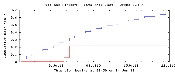
Don't believe me? Here are plots of normal (blue line) and actual (red line) for the past four weeks at Seattle, Stampede Pass, Yakima, and Spokane. Each location has had far less precipitation than normal and virtually nothing the past ten days.
Or take a look at the official National Weather Service precipitation plots for the last 30 days. The whole West Coast has been far drier than normal (25-50%).
My garden is wilting fast, my grass is turning yellow, and my soil is like dust.
So lets stop complaining about the cool weather. And besides, on most of the cloudy mornings west of the Cascade crest you could easily escape it by hiking in the mountains or exploring eastern Washington.
Talking of dry weather, keep in mind that the climatologically driest period is still ahead: the last week of July and first week of August. The driest day in the west? Well in Seattle it is July 29th, my favorite day for a "dry sky barbecue."
Still want you heat? NO PROBLEM. We will have a little cool down tomorrow, with persistent low clouds, but on Friday we move into a warming trend, with the weekend and much of next week warm and sunny...certainly above normal.
So hopefully all the complaining will fade away during the next few weeks---it should be spectacular if you like dry conditions and sun. If you don't, just wait a few months.
Stephen Schneider and Me in 1974 at NCAR, Boulder ,CO
This is going to be a more personal blog than normal and a sad one for me. Yesterday, Stephen H. Schneider, a very prominent climatologist and someone who had a major impact on my career passed away. Steve was one of the key individuals in bringing the issue of global warming to the world's attention. There are few scientists who are technically at the top of their field, accomplished communicators of science to the public, and conversant with public policy: Steve was one of the them. He was a member of the prestigious National Academy of Sciences, a winner of the MacArthur "Genius" award, a leading participant of the IPCC deliberations on the science and implications of global warming, and a co-winner of a Nobel Prize. Author of a half-dozen major books and hundreds of research papers.
But as important as his accomplishments were that is not what I want to stress here. Rather, I will discuss my personal account of interactions with him and the major impact he had on my career.
After my senior year as an undergraduate at Cornell I was accepted in a summer internship in scientific computing at the National Center for Atmospheric Research (NCAR). A major part of the summer was working with an NCAR scientist and I was assigned at random to Steve--an amazingly lucky break for me-- not that I knew it at the time. He was fairly new at NCAR, having recently graduated from Columbia in plasma physics, and had moved into atmospheric sciences and particularly climate.
Steve gave me a desk in his office and took me under his wing (see picture above). My project was to reprogram a global climate model he had developed and I dedicated myself to that task, staying up many nights until 2 or 3 AM in the morning. And I loved it. Steve made me feel like an equal and we spent hours talking that summer, both in the office and at social stops at his home. One major topic--the essential role of the public scientist and of communicating science to the public. Even then he was becoming the "go-to-guy" for the national press on climate matters, and the media was constantly calling. Listening to him deal with them taught me so much on being an effective communicator.
The results of that summer work led to a paper on the influence of sunspots, volcanic eruptions and CO2 on climate (published in Science Magazine)--still my number one cited publication. We kept in touch after that program and he invited me to come out to work with for a second productive summer, with the work leading to our second paper, mainly on volcanic eruptions and climate.
His influence on a young impressionable future scientist was powerful--I become intrigued by subject of climate and importantly became convinced that scientists must put considerable energy into communicating their subject to the public for a whole collection of reasons.
After I received my Ph.D. from the UW, I did a few climate papers (particularly on the weather and climatic impacts of Mt. St. Helens) but moved into other directions (weather prediction, NW weather, weather systems) and occasionally saw Steve at meetings. But I still had the climate bug he implanted and during the past few years have return to climate in the areas of regional climate modeling and snowpack trends. And his influence played a major role in my intense dealings with the media (e.g., KUOW), my NW weather book, and my blog.
A few months ago I gave a talk at Stanford (where Steve was a faculty member) on regional climate modeling and had a chance to catch up with him. His fight against cancer had clearly weakened him, but he was as feisty as ever, complaining loudly about the shenanigans of Oklahoma's Senator Inhoufe, who had placed Steve and a few other climate activists on a watch list of some kind.
Steve had a huge impact on both science and society, and was not a little controversial at times. But his intelligence, energy, and passion were unstoppable and productive, and the kindness and inspiration he provided to a young scientist will not be forgotten.
What could be more depressing than a well-meaning corporation and a closely associated foundation, concerned about the quality of math education in our nation, applying a large amount of resources that are not only wasted, but generally have exactly the opposite effects that they want?
That is the sad tale of Microsoft and the Bill and Melinda Gates Foundation.
To quote Brad Smith, a senior vice president and general counsel for Microsoft:
"We're very concerned about the possibility that our kids are falling behind in areas like math and science," he said. "We urgently need to tackle this as a region, as well as a state and as a country ... but it's not a problem that's impossible to solve."
The Gates Foundation web site is full of similar sentiments.
These folks have good intentions.But they are making major errors and working against their own and the nation’s interests.
For example.Microsoft has teamed up with the University of Washington College of Education and eight school districts in the Puget Sound region in the Microsoft Math Partnership (MMP). As part of the partnership, Microsoft is donating $6 million over three years.It is well known that the UW College of Education promotes demonstrably failing reform or discovery math approaches (http://education.washington.edu/research/rtm_07/index.html) and it is clear from the MMP website that this initiative follows that failed direction (http://www.microsoftmathpartnership.org/).Read the summary of the first two years’ efforts (http://www.microsoftmathpartnership.org/partnereval.php).One of the main aspects of their work is hiring math "coaches" who “are more confident in the expectations for their work with teachers on instructional practice and are starting to create collaborative teacher teams around common goals.”
Math coaches are big part of the reform/discovery math approach.Since reform math ideas generally don’t work, they have concluded that teachers need the help of “coaches.”In my mind this is kind of insulting to professional teachers.
The MMP website says virtually nothing about the key deficiencies in math education: poor curricula and standards. There is a lot of talk about the importance of 8th grade algebra as a “gatekeeper,” but what exactly should students know BEFORE and AFTER they take this class?You won't find the answer at the MMP website. Amazingly, the latest MMP annual evaluation shows district math WASL scores in the years before and after this program, somehow implying their program had a positive influence.How can they claim that this program had ANY positive influence on student scores ?No randomized studies are performed. But this is classic educational research, which is really no research at all.Interestingly, most of the districts in the Microsoft initiative have been using weak Discovery Math approaches (where students are not provided direct instruction, but are expected to discover math principles on their own with heavy use of calculators). Why don't the Microsoft folks see that with a weak curriculum all the coaches in the world won't help?
Now, what about the Gates Foundation?They have loads of money but are highly dependent on advisers and staff taken from the failing educational bureaucracy…and are making and remaking serious mistakes.Some of you may have heard of their initiative to improve high schools by breaking large ones into smaller academies.After spending hundreds of millions dollars on this initiative (http://www.msnbc.msn.com/id/38282806/ns/business-bloomberg_businessweek/), it has proven to be a failure.Even Bill Gates says so.
Now perhaps national math standards could be a good thing if they were strong, comparable to nations that lead the world in the math competency of their students. But the current version of the U.S. Dept of Education’s Common Core math standards is not strong.In fact, they are far weaker than the new WashingtonState math standards that we have worked so hard for.And weaker than those of California, Indiana, and other states with world-class standards.
Academic standards should clearly and coherently define the course-by-coursecontent students should know after taking that course. Instead, the common core high school math standards only provide a general summary of which subjects a high school student should master.
A careful examination of the Common Core standards reveals huge gaps in key topics.Although the Common Core standards include the use of standard algorithms for addition, subtraction, multiplication, and division, they are one year too late, and do not require division until the 6th grade. There are huge gaps in important topics such as the mastery of fractions. Common denominator is mentioned only once in the standards and students are never explicitly required to find one I could give you a dozen more examples, but you get the message.
Because the Common Core lacks specificity and structurethey are essentially useless for developing a reliable and valid assessment. States are lining up to join the Common Core bandwagon for only one reason—the huge purse the Dept of Education will divide among Common Core participants.
When you check out the Gates foundation site there is little discussion of the importance of good curricula and books.No objective comparison of U.S. standards with those of leading nations, no support of randomized studies of the effectiveness of various math instruction approaches.Just a lot eduspeak.As a scientist accustomed to rigorous research with solid statistics, it is maddening.
The key to turning the current math education debacle around is to adopt good, coherent standards modeled on the top performing nations in mathematics; adopt good curricula, based on the standards, using research-backed teaching methods; and adopt assessments, also based on the standards, that will allow us to ensure our students are progressing as planned. Next in importance are well-trained teachers, who know their subject. Instead of paying for math coaches, we should be paying for ongoing education for teachers to increase their knowledge in the subjects they are teaching. And we need a change in the educational bureaucracy in which REAL research, guided by sound statistical design, helps guide the discipline.Perhaps one day, Microsoft and the Gates Foundation will not be guided by the latest unfounded trends in the failing educational bureaucracy fostered by the weak education schools of our nation.The problem CAN be turned around, but a rigorous, rational course is required.
Good intentions are important, but effective actions are what really count.
It is interesting to look at the recent temperatures across the Washington State and huge variability one sees.
Lets start with Quillayute (Forks) near the coast (see graphic). For most of the past two weeks it has been cooler and cloudier than normal, but they had that amazing heat wave between July 6-10th in which they greatly exceed the normal max temps..one day even getting above 90F. To do so requires offshore flow and they had that in spades that day. Then there is Seattle (graphic). Quite a bit better. We had the heat wave of course, but we also had some recent nice days. Average the last two weeks...give one average conditions. Try Pasco in the Tri-Cities. Close to normal overall, with some days getting to near 100F. This time of the year, you can nearly always find warmth east of the Cascades. Saturday (tomorrow) should be decent, starting with low clouds in the west and burning back except for the coast. Temps reaching into the lower 70s.
But late Saturday and early Sunday an upper trough will pass through, substantially deepening the marine layer. The computer models indicate substantial low clouds over western Washington at 8 AM on Sunday and it will be very slow to burn out. Mid-afternoon clearing if we are lucky, with temps only getting up near 70F.
There is no heat for us in the offering. Models show general weak upper level troughs (low pressure areas) over our region. Forget 80s west of the Cascades at low elevations. But some Cascade hikes will be high enough to get one out of the morning murk. And perfect conditions for the Seattle to Portland bikers.
For those of us who love the weather, what could be better than a restaurant dedicated or named after our favorite interest? Here in the Northwest a number of dining establishments are weather oriented and in this blog I will describe only a few.
Well, I might as well start off with my favorite, a weather theme restaurant with a wonderful location for experiencing storms AND good food: Ivar's Mukilteo Landing restaurant--in Mukilteo right next to the ferry dock. This restaurant has a real weather story...the original facility was destroyed by surge of strong westerly winds that moved from the Pacific down the Strait of Juan deFuca on October 28, 2003. Ivar's management decided to rebuild it and to do so with a decided weather theme. You enter the restaurant and on the right there is a huge mural illustrating the giant waves that pummeled the restaurant that day. On the left, a wall of newspaper articles describing the storm and the destruction. This entry way is enough to get even the most tepid meteorologist salivating.
A little further you will find a panel of working weather instruments. There is a note that if the winds exceed a certain speed that you should push the red warning button and go back to your table and order dessert. My kind of place. And there are big windows facing the water to the west and northwest, also giving a good view of the arriving and departing ferries. On a stormy day you would have quite a show. And here is the surprising thing--with all the meteorological fun this restaurant has really good food. So Ivar's Mukilteo Landing is clearly my top choice.
(2) For all its strengths, Mukilteo Landing has one weakness--the name says nothing about weather. No worry. You can eat at Forecasters Public House in Woodinville. Located in the Redhook Brewery Complex next to St. Michelle Winery, you will find a sign showing an old New England meteorologist in serious rain gear.For good or for bad, this place hasn't been destroyed by weather yet, although its proximity to the Samammish slough leaves open the potential for flooding. There are weather instruments inside the door and lots of the wet stuff (Redbook beer). I asked the individual at the gift shop whether they were interested in carrying my book...and she laughed (not a good sign). The food is typical brew food: ok, but not great, but there is a nice deck for eating and drinking in warm weather. And you can always sign up for the brewery tour.
(3) If you are looking for a a more tropical weather experience, you could go to the Hurricane Cafe in downtown Seattle.
For breakfast they offer dishes like the "Typhoon" and "The Storm" and for lunch and dinner there is the "Hurricane Burger" and the "Hurricane Sampler." I haven't eaten there but let me quote from an online review: "As dives go, my dining experience was surprisingly awesome."
Well, there are many more I don't have time to review--the Convergence Zones lanes at Whidbey Island Naval Air Station for instance (and they serve food there)
(There used to be a Convergence Zone tavern near Paine Field, but that is closed now).
Or a nice cup of coffee at the Rainshadow Coffee Company in Sequim:
Of course, there are plenty of good restaurants for watching the weather in the Northwest...but that is another blog. If blog reader know of other weather eateries...let us know in the comments below.
Ever notice than when cool, cloudy conditions move into western Washington during the summer, eastern Washington weather can become very active with strong winds, wildfire blow-ups, and sometimes dust storms? Well, it happened again today!
Earlier today a weak cold front/trough moved through the area. Cool air and high pressure spread into the west side of the state, with a lot of it blocked by the Cascades. As a result a large pressure different built across the Cascades (see model forecast for 11 AM this morning).
Air accelerated across the crest and even more so in gaps in the mountains...the most prominent of which in the central Cascades is Stampede Gap east of Snoqualmie Pass. Air accelerated into CleElum and further strengthened as it pushed into Ellensburg...with some with gusts reaching 50 knots (around 58 mph). Lesser winds (20-40 mph) descended some of the eastern Cascade foothills, with strong winds (15-25 mph) over substantial portions of eastern Washington. Here is 6-h forecast of the sustained (not gusts) surface winds, valid at 11 AM.
The strong winds unfortunately help further stoke the Swakane fire north of Wenatchee to 12000 acres (see below).
Furthermore, dust was raised elsewhere in eastern Washington, such as near Soap Lake. Take a look at the picture at the top of the blog--you can see the smoke (greyish white and the dust--light brown).
Strong winds like today are also good for the wind energy industry as long as it doesn't get TOO strong. Then they have to feather the turbine blades to reduce stress on the structure.
In any case, the winds should fade back tonight and tomorrow, which should be helpful to those trying to get the fire contained. But it should not be forgotten that sudden acceleration of winds associated with cool air moving into the west can cause eastern Washington fires to explode or move rapidly--and that is why NWS meteorologists and other professionals are assigned to all significant fires, playing crucial roles in protecting the lives of firefighters.
Finally, if any of you are interested, I will be one of the instructors this summer (August 5-8) at the North Cascade Institute's Northwest Naturalists Weekend: Weather, Wildfire and Biodiversity. I will provide a series of talks on NW weather and the other instructors will be talking about effects of wildfires and about lowland forests. Plus, hikes and canoe trips and good organic food in a beautiful location. For more information go to: http://www.ncascades.org/programs/seminars/course.html?workshop_id=1018
Although some forecast outlets are going for a major cool-down into the 70s from todays 93F....it is looking more and more that it is going to be much warmer tomorrow than expected. At the point I would predict low to mid 80s...and 84F would be a good number for Sea Tac.
Why do I say that? The onshore push tonight will be exceedingly weak...that is evident by the lack of an onshore pressure difference. The clouds moving in overhead will work against nighttime cooling. Computer models only suggest a modest cool down aloft. And the thin stratus deck offshore evaporated this afternoon. There will be very limited low clouds tomorrow am. So plenty of sun through the remnant of the middle level clouds moving through aloft. So don't get rid of your fans yet....in fact, I purchased one tonight myself! (Sales tip...Rite Aid has a sale on fans)
With the middle level clouds, somewhat more humid air, and lack of wind, it really feels like an East Coast summer tonight...yes, not quite as sticky...but it is reminiscent.
Sunday will be a step down, with a far greater chance for morning low clouds. But they will probably burn off by mid-day and temps should climb into the mid-70s.
Today was a scorcher, but tomorrow (Friday) should be a few degrees cooler...still hot, but a bit more tolerable.
The thermal trough has now jumped into eastern Washington and there is now a weak onshore pressure gradient...which will push somewhat cooler air into western Washington.
Sea Tac Airport is 3 degrees cooler than the same time last night.
The Sand Point Profiler winds show a tremendous change (see graphic). This figure shows you how the winds above Seattle have changed in time. Time in GMT increases to the left and the heights are meters.
The warm easterly winds are gone and the winds aloft are now southwesterly, with northwesterly winds at low levels. These are much cooler wind directions this time of the year.T here is NOT going to be a major marine push tonight and thus you will have to be girded for one more hot day. Want cool? Head to the coast, where low clouds and temps in the 60s will be the rule.
Thursday AM Update: Temps this morning are running about 5-7F ahead of yesterday, so today will peak in the lower to mid 90s for most. Low clouds on the coast, where it is much cooler today...a sign of the changes coming
This week we are having the perfect heat wave--long enough to get the feeling of warmth, but short enough that our homes and apartment won't heat up completely before the cool-down occurs...and there will be a substantial one on Saturday.
Tonight I am cooling down my house with lots of fans. I find that by putting on all the bathroom fans (which draw heat out of the house), coupled with four box fans in windows blowing cool air in, I can quickly get the house down to a decent temperature. The key with heat waves is to cool the house down at night...and to get shades down on the sunny side during the day. If the interior spaces warm up, you are toast...so to speak. I just watched Jeff Renner and he also suggests eating spicy foods. The theory is that it makes you sweat (as if we needed help doing that in hot weather!). So buy some fans and some 5-star Thai food and you should be good.
As advertised, today we warmed up into the upper 80s to lower 90s in the region. Take a look at the regional temperatures at 5 PM...near the time of maximum warmth. Click on the image to expand it. With offshore flow, even the coast was warm and Portland and Willamette Valley was way warmer than Puget Sound country. Why is the Willamette so torrid? The reason is that they don't have the proximity to water through a low-level passage. It is often 5-10F warmer there than near Seattle.
The warmth will continue tomorrow (Thursday)....I expect the temps to be very similar to today.
Below are the pressure and temperature plots for this afternoon and Thursday afternoon.....warm temperatures for both. At 5 PM today the thermal trough extends from the Willamette Valley into western Washington and easterly flow descends the western slopes of the Cascades. A very warm pattern.
Thursday afternoon we are still warm and the thermal trough appears split between western and eastern Washington.
On Friday, the trough of low pressure over western Washington "jumps" into eastern Washington and greater onshore flow will occur.
Expect Friday to a be a few degrees cooler. This process continues over Friday night and Saturday should be WAY cooler, with low clouds in the morning and temperatures in the upper seventies.
One final thing...some people like to make fun of meteorologists...saying their forecasts are wrong 50% of the time. Lets face it, my profession nailed this one....days ahead!
This year it will be very easy to note the start of summer in western Washington---it will be Tuesday, July 7th. We are just about to make the big summer transition and the change will startle you....somewhat like a meteorological slap to the face.
Today, it got to 65 at the airport, when 74F is typical...9 degrees below normal. But for the remainder of the week we will be on the other side of the climatological divide, with temperatures rising into the mid-seventies tomorrow, 80s on Wednesday, and near 90F on Thursday. Let me show you some of the weather maps and describe a key feature of our heat waves...the west coast thermal trough...an area of low pressure associated with low-level hot air. I have written quite a bit about the thermal trough in scientific papers and in my book, and currently a graduate student of mine is doing a comprehensive study of this key feature of nearly all NW heat waves. Take a look at surface pressure maps for the next few days. These maps also include near surface winds and low level temperatures (color shading). Temps are in C (20C is 68F, 30C is 86F) Lets start with this afternoon at 5 PM. Warm over the SW U.S. (red and brown colors!), but yellow (cool) over the NW with higher pressure offshore. There is a huge pressure difference off of N. coastal CA with very high winds...but that is another story. No heat wave for us. Next tomorrow (Tuesday) at the same time. See the difference, we have gone from yellow to orange. See the tongue of lower pressure moving northward into the Willamette Valley...that is the thermal trough. Why a trough? Because warm temps are associated with less dense air which results in lower surface pressure. Why is the air warming? Two reasons: high pressure aloft is producing general sinking and warming of air (by compression) is the first. And there is easterly flow developing over the Cascades, which produces enhanced sinking (warming) on the western slopes. Here is Wednesday afternoon: we are now in pinks and the thermal trough is right over us, with easterly flow over the Cascades. We could get to the upper 80s with this pattern, especially over the eastern PS suburbs. Portland will be very, very warm with this....well into the 90s. And then finally Thursday afternoon....very warm over the whole region. Certainly upper 80s, lower 90s for the PS region away from the cold water. But something subtle is changing...pressure is falling more over eastern Washington. Might the thermal trough jump the Cascade, leading to a cool down on Friday or Saturday? Keep tuned!
 9AM view in Seattle looking toward Mt. Rainer
 noon--brightening up
 3PM: cool, cloudy air all mixed out and some convection over the mountains.
 By the way, those in western Washington could have looked eastward and seen some instability clouds (cumulus) over the Cascades later in the afternoon today.


.gif)

