May 31, 2010

Weather Retribution

It is clear than our region has offended the great weather god.

First piece of evidence: the below normal temperature and above normal precipitation of the past 1-2 weeks (see graphic of temperatures at Seattle Tacoma Airport compared to average high and low). For the past ten days the maximum temperature has remained well below normal.But what is remarkable, is that this run of cold and damp is not going to end soon.
Tomorrow will be decent, with partly cloudy skies and few scattered showers. But Tuesday night and Wednesday a strong wet system will cross the area. Take a look at the forecast 24-h precipitation ending 5 PM Wednesday.
Thursday is a break day and then an REALLY strong system hits on Friday...and may be a powerful windstorm on top of rain. Here is the latest (Tuesday noon) output from the UW high-resolution forecast model for 5 AM Friday. A 990 mb low center right off our coast, with strong coastal pressure gradients. I also have the forecast winds--40 kt sustained along the Oregon and southern WA coasts! This is intense weather for June.


Want some good news?...no major weather feature over the weekend.

May 29, 2010

Not Good

I am afraid I am going to have to update the forecast substantially...and the changes are not good for tomorrow.

Yesterday was very wet, particularly over NW Washington...take a look at the 48-h rainfall ending Saturday morning from RainWatch (www.atmos.washington.edu/SPU), a system we developed for Seattle Public Utilities (see graphic). Some places--N. Whidbey and nearby locations--had 1-2 inches of rain. I had some people asking why the rainshadow area was so wet. The reason: the winds yesterday were from the north and northeast and Sequim and N. Whidbey were no longer in the rainshadow of the Olympics.

Now lets get to the depressing forecast. Right now (Saturday morning), there is considerable cloudiness over the region (see image). With NW flow aloft the rainshadow is now TO THE SE of the Olympics where it is normally wet (so head to Shelton!) There is clearing over eastern Washington to the east of the Cascades as well...a very good place to be today. Drier air is moving in from the west, and the situation should improve starting at the coast. Upslope flow should keep clouds and light rain over the western slopes and crest of the Cascades and a Puget Sound convergence zone could keep some clouds and showers over northern Puget Sound.

Eastern Washington still looks good.


But that is pretty much the same story as I told you yesterday.
The problem is that the next Pacific disturbance is moving in faster than initially forecast. Here are the new forecasts for 3-h precipitation for tomorrow, ending 8 am, 11 am, and 2 PM. The rain is on the coast by daybreak and moves into western Washington during the morning. Eastern Washington remains dry on Sunday.

This situation is a good example of a timing error in our simulations--the system is coming in about 6-hr earlier than suggested by yesterday's forecast model run. And on top of it all, the NWS weather radar at Camano Is. is broken again. In such situations I look at the Canadian radars:

http://www.weatheroffice.gc.ca/radar/index_e.html?id=WUJ
or the Portland radar.


Monday will be showery and generally cloudy, with a few sunbreaks, particularly in the afternoon.

Anyway, the Sunday window is closing...do something right after breakfast and you might be fine, but by lunchtime the murk will be back.

May 27, 2010

Memorial Day Weekend: One Day Out of Three


What a difference a year makes.

In 2009 the last week of May was nearly dry with temperatures above normal. 2010 will not be a repeat, unfortunately. I think we have a very good idea now of what will occur, and the weekend is going to be a mixed bag.

Lets start with Friday. WET. In fact, quite wet.

Rain will be moving in overnighttonight and will stay around most of the day over the western side of the state. Here is the 24-h rainfall ending 5 PM tomorrow.

Amazing amounts of rain (1-4 inches) over the N. Cascades, with bountiful amounts rotated into NW Washington. Even eastern WA will get a good soaking. So if you are going to take Friday off to enjoy of four-day weekend, don't plan any picnics or barbecues. Or surprise your boss and say you would rather work.

So cross off Friday.

Saturday will be better, which will not be hard to do. Here are the three-hour rain forecasts ending 8 AM and 2 PM (below).


Showers will be continuing over the mountains and western slopes, with some showers over the lowlands. Mostly cloudy. If you can head to eastern Washington you can do better, with sun and temps rising into the 60s (except the northern portion).

The 24-h rainfall ending 5 PM Saturday is shown below. Still plenty of liquid sunshine.

Sunday will clearly be the best day of the weekend. It will be dry during the first part of the day in the interior with light rain approaching the coast during the afternoon (see graphic of 3-h precipitation ending 5 PM), associated with an approaching Pacific system. Sun and temperatures in the mid 60s west over the western interior. Dry for hiking.

Monday, Memorial Day, will be cloudy with light rain, with temperatures falling back into the lower 60s.

Memorial Day weekend has never been dependable around here and probably never will be, but by maximizing outdoor recreation on Sunday and heading east of the Cascades on the others, you could have sun every day.

May 26, 2010

Looking Better for the Memorial Day Weekend


Well, the forecast is looking up for Memorial Day, so it looks increasingly that you will be able to enjoy that picnic, trip, parade, or other outdoor activity. Not perfect, no heat wave, but good enough, and considerably better than the outlook a few days ago.

But there is a real lesson in this--we have to be within 3-4 days to have some confidence in the forecast. Right now it looks like there will be considerable showers on Friday, with a convergence over the north Sound and lots of showers on the western side of the Cascades.

Saturday will star out with some showers, but by 3 PM, the region will be mainly dry.

Sunday looks good...dry and temperatures well in the 60s. That is the day to plan to main outdoor fun. Clouds increasing later in the day and perhaps showers reaching the coast late in the afternoon.

Monday will have some showers.

May 24, 2010

Approaching Front and Some Light Rain

ANNOUNCEMENT: Puget Sound Chapter of the American Meteorological Society Meeting Wednesday night!

PRESENTATION: "The West Coast and Alaska Tsunami Warning Center: How We Warn the Nation." Cindi Preller - West Coast/Alaska Tsunami Warning Center

DATE and TIME: Wednesday, 26 May 2010, at 6:45 PM PDT.

LOCATION and LOGISTICS: The meeting will be at NOAA, Building 9 Auditorium, starting at 6:45 PM. Don't be late! You must be on campus by then since the gates are locked at 7 PM and there won't be anyone to let you onto the NOAA Campus.

The address for NOAA Campus is 7600 Sandpoint Way NE

My blog:

I wish I could report either a heat wave or a big storm like last weak...alas...just cooler than normal weather and some light rain are in store for us. Here is the latest infrared satellite picture:

The front, impressive looking in the infrared imagery, is in reality fairly weak and leads to a low pressure center in the Gulf of Alaska. Not a good day for an Alaskan cruise. The radar is now in clear air mode, which has a different look from the normal "precipitation mode" settings. Some light precipitation is coming in now, and rain is reported on the coast. Clear air mode, as I noted last week, allows us to see weaker features, even insects, weak shear lines, and birds.


But let me cut to the key issue..how does Memorial Day weekend look? Right now it appears that the showers will end early Saturday and that this day will be decent with a weak ridge building over the area. But by Sunday afternoon a weak front will make landfall, bringing showers. Timing such features are difficult, but at this point there is NO reason to expect a major warm-up over the weekend....sorry.

Going to eastern Washington might be a nice break from the cool,rainy conditions of the west...but then there is the construction on I90!

May 22, 2010

Cool and Convergence

I hate to say this...but this has been a classic May in some ways: cooler than normal in the beginning, a warm spell mid-month, and a cool down at the end. Take a look at Seattle's temperatures versus the normal highs and lows (below) to see what I mean.The last few days have been roughly 10F below the normal maximum (which is around 65F).

My tomatoes are fading.

The windstorm was of course not the usual May fare. Why so cool and showery? The reason is that a broad upper level trough or low, with associated cold air aloft, that has been parked over the western U.S. (image below). This same pattern is producing a heat wave over the eastern U.S.
And I don't have particularly good news for you..there is no real warmth in sight and another cold trough is headed our way!

Today's situation is made clear by the latest visible satellite photo (below). Sunny east of the Cascades (an excellent place to go during cool spring periods). The influx of cool, moist air has produced clouds and light showers on the western side of the Cascades and the crest, and westerly flow is producing a weak Puget Sound convergence zone, something evident in the latest radar image (below). Cool, unstable air is approaching from off the Pacific. So outside of the convergence zone Saturday will be partially sunny, cool day with highs in the upper 50s.
The convergence zone and showers should rev up later today and tonight (see forecast precipitation below), and more clouds and showers are expected Sunday.
Monday should be the best day as the upper trough moves out.

But THEN another cold upper level trough moves in mid-week (see upper level map for Wednesday)...and you know what that means....

May 19, 2010

Powerful Storm

The storm is now is moving into Vancouver Island and the model forecasts verified quite well. Below is the latest infrared satellite picture...you can clearly see the low center. Beneath that is the visible satellite photo at 5 PM. Really impressive... you can see the swirling clouds and the strong front that had just passed through Puget Sound.
The winds did not disappoint. Destruction Island off the NW Olympic coast hit 72 knots (see below)...that is 83 mph! Hurricane strength gusts (to be fair hurricanes have sustained winds greater than 64 knots)

A number of the coastal buoys had gusts of 50-55 knots (58-63 mph) with similar winds at some exposed coastal locations).

Winds are really surging now over NW weather, with several locations in the area from N. Whidbey to the San Juans being hit by 40-60 mph gusts. Take Point Wilson on the NE tip of the Olympic Peninsual for example--almost up to 50 kts! (see below)

Even over the waters of Puget Sound, things are pretty wild tonight...check out the latest ferry observations from the Fauntleroy-Southworth ferry-- 38 knots in mid-channel but only 8 knots downstream of Vashon Is....and even less over land.
This is something you should never forget..the winds blow much harder over the water. We are all very lucky to have weather observations from the WS Ferries, a great teacher and promotes marine safety.

There have been a number of power outages over the region affecting thousands of customers. If any of you have interesting wind reports, please report them in the comments below. Here is a max wind collection from the National Weather Service:

PUBLIC INFORMATION STATEMENT
NATIONAL WEATHER SERVICE SEATTLE WA
1240 PM PDT THU MAY 20 2010

..MAXIMUM PEAK WIND GUSTS FROM AROUND WESTERN WASHINGTON WEDNESDAY
AND WEDNESDAY NIGHT...

OFFICIAL LOW LAND AIRPORT OBSERVATION SITES.

QUILLAYUTE 60 MPH
HOQUIAM 60 MPH
WHIDBEY ISLAND NAVAL STATION 49 MPH
BELLINGHAM INTERNATIONAL 49 MPH
TACOMA INDUSTRIAL 47 MPH
FRIDAY HARBOR 43 MPH
EVERETT / PAINE FIELD 43 MPH
SHELTON 41 MPH
ARLINGTON 37 MPH
MCCHORD AFB 36 MPH
SEATTLE FORECAST OFFICE 36 MPH
PORT ANGELES 35 MPH
RENTON 32 MPH
OLYMPIA 32 MPH
BOEING FIELD 31 MPH

NATIONAL WEATHER SPOTTER REPORTS
AND MESOWEST

ENUMCLAW 65 MPH
OCEAN SHORES 59 MPH
PORT TOWNSEND 56 MPH
LA PUSH 55 MPH
BELLINGHAM 54 MPH
BOTHELL 51 MPH
SANDY POINT 49 MPH
COPALIS BEACH 48 MPH
LYNDEN 43 MPH
CHERRY POINT 40 MPH

MOUNTAIN OBSERVATIONS

HURRICANE RIDGE (RAWS) 118 MPH
HURRICANE RIDGE (NWAC) 83 MPH
MOUNT BAKER (NWAC) 78 MPH
WHITE PASS (NWAC) 55 MPH

MARINE OBSERVATIONS
DESTRUCTION ISLAND 70 MPH
TATOOSH ISLAND 62 MPH
SMITH ISLAND 52 MPH
POINT WILSON 50 MPH
WEST POINT 40 MPH

$$

Even Stronger


The latest satellite pictures shows a profound enhancement of the high clouds around this system (see above). The latest forecast models are even more threatening that last night...this is going to be a major coastal wind event, with damage and power outages. NW Washington will be hit harder than expected last night. And another issue...when the low is offshore, winds will accelerate to the west in the Strait of Juan de Fuca.
The National Weather Service has now put storm warnings for the entire coast and the western Strait of Juan de Fuca.

Here is the latest forecast for 5 PM tonight...pretty amazing. 989 mb low and a huge pressure gradient to its south and southeast. The simulation indicates even stronger winds than last night, with areas immediately offshore experiencing 60 kt sustained winds and hurricane-force gusts.

Unfortunately, most of the offshore weather buoys are broken (this is really a problem!)--that is why we need coastal weather radars! The best buoy (46089) we have now is about 90 miles west of Tillamook, Oregon and the winds there are speeding up fast (30 kts last hour).

May 18, 2010

A Serious Storm

Long Beach will be vulnerable to this event

The models are all on the same page now, confirming that the Northwest...and particularly our coastal regions...will be dealing with a serious storm event. There are some unusual aspects of this storm I want to talk about and some misconceptions that need to be cleared up.

First, a storm this powerful in middle May is quite unusual, but not unprecedented.

Second, although the central pressure of this storm will be modest by winter standards (the current forecast is for around 992 mb), the differences in pressure that drive the winds will be first class. The reason? The environmental pressure...the pressure in the neighborhood... is relatively high (partially because of the season) and thus the difference of pressure between the low and its environment will be very large.

Bottom line: this storm has big coastal wind potential. (If you want to learn more about pressure gradients and winds, check the windstorm chapter of my NW weather book) It will not be the equal of the mega events (Dec 3-4, 2007, Inauguration Day Storm), but will be one of the strongest storms this year.

Third, the path of this storm is not right for a major windstorm over Puget Sound. To do so, the low would have to cross between the middle of Vancouver Island and the NE Olympic Peninsula. This low is too far offshore. But the zone of very large pressure gradient--located south of the low center-- will swing up along the Oregon and Washington coastlines, producing powerful winds. As I will show below, the strongest winds will hit the northern Oregon and southern Washington coastal zone. We are talking sustained winds of 35-60 kts, with gusts that could reach 70-80 kts. I would not be fishing out there tomorrow afternoon and evening, and I would not be surprised if some power outages occur along the coast. The NW interior of Washington (Whidbey, San Juans) will also be hit by strong winds...but nothing like the coast.
Finally, the fact that leaves are on the trees will make them more vulnerable to wind damage.

It would be great time to head to coast to experience some real weather.

So let me show you the latest forecast output.

To start, here are the pressure forecasts from the UW WRF forecast model for 5 PM and 11 PM tomorrow (Wed) night. Very large pressure gradient along the southern flank of the storm, with the gradient concentrated in what we call the bent-back trough (a.k.a., the poisonous tale of the bent-back occlusion). The pressure gradient is largest over the offshore waters and sweeps northward along the Oregon and Washington coasts. The Puget Sound interior will get a piece of the action, but a small one (perhaps sustained winds of 20-30 kts). Coastal winds will start as southerlies and southeasterlies and then swing to westerly as the low moves northward. An associated front will move inland late in the afternoon, bringing moderate rain and colder air behind. (I won't even go into the rain and snow aspects).

Next the wind speed graphics at the same time. Impressive for a late season storm. Blacks are sustained 45 knot winds..with higher gusts. The Long Beach Peninsula is going to get nailed. I really hope that one of the TV stations sends one of their teams there. As the low moves northward the strong winds will follow (see second image)

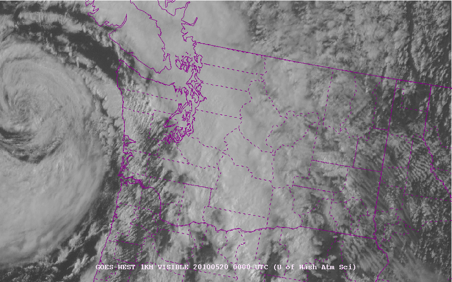
Here is a close-up view of the winds over western Washington. As the low moves northward, winds in Georgia Strait will become strong, with sustained winds of 30-40 knots in some places. Residents of the San Juans and northern Whidbey Island should be ready for a modest blow.


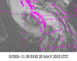
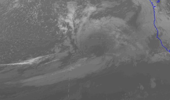
Finally, there is something really weird about this storm in the satellite imagery. You can see the storm in the visible imagery (below), but it is completely unimpressive in the infrared (image). I can't remember seeing such a potentially strong storm have such a modest satellite imagery. Are we missing something? A reflection of the season?

Visible

Infrared

May 17, 2010

Storm Update

The new run is in and the forecast is basically the same as this morning. Thus, it is looking increasingly likely that a good windstorm is coming to the coast and NW Washington-an unusually strong one for this time of the year.

Here is the latest forecast from the UW high-resolution forecasting system for 8 PM Wednesday. An intense pressure gradient is evident from SE to SW of the low center. The coast will get hit hard.


How hard? Here are the surface winds for Wednesday afternoon and evening. Pink color is SUSTAINED 40 kt winds! In the afternoon, there are blacks offshore-- 45 kt sustained! And the gusts could be much greater (55-65 kts).


Away from the coast, strong SE winds will buffet NW Washington...here are some graphics for you to view for 8 and 11 PM on Wednesday night. 30-40 kt sustained winds near the water. Plus higher gusts.


Now, nothing is certain and we need to watch tomorrow's model runs, but at this time it really looks like a strong blow on the coast and NW Washington. And there will be substantial rain with the associated frontal system. Good for the plants. Hopefully my tomatoes will survive--I planted them last weekend.

Major Coastal Blow Possible On Wednesday

I will update this more tonight...but an unusually strong low pressure system...and strong winds...will reach our coast on Wednesday. Also strong SE winds over NW Washington. See pressure forecast below for 5 PM on Wednesday. More tonight. The models are still shifting the low position, so there is some uncertainty in this forecast. But if you are on the coast, planning an offshore fishing trip, or living in the region from northern Whidbey Island to the San Juans...keep tuned. And it will be windy over the rest of western Washington.

A lot of isobars!

Here is a wind speed map for 8 PM on Wednesday...sustained winds of roughly 45 kts on the coast, which would mean gusts to 60 or more. Each run has brought the low farther south--which is more threatening. Will see what tonight's forecast indicates.


May 16, 2010

There is a bird in my radar!

During the past few weeks, several of you have asked essentially the same question:

" It's been completely dry but the weather radar last night showed lots of echos, suggesting it rained all night. What is going on ?"

Well, I can give the you the answer: Birds!

Weather radar can see more than raindrops. It can see the mountains, but that signal is generally removed successfully (terrain clutter) since the mountains generally don't move. Weather radar can see other objects in the air and the amount of return generally increases by the sixth power of the object's diameter. (Doubling the size of an object increases the amount of the radar signal scattered back increases by 64 times). Since a bird is much bigger than a raindrop, you can imagine that it would provide a good return.

Another point. The weather radar used by the National Weather Service has two modes: clear-air and precipitation. Clear air mode is much more sensitive and is used when it is not precipitating to get some information on the winds. In this mode, discontinuities in the atmosphere (e.g., where density changes rapidly) and bugs (which get blown about by the wind) can show on the radar (within tens of km of the radar site) to provide some useful information.

But now we get to the birds. During dry periods the radar is on the hypersensitive clear air mode and during the night (particularly during migration periods in spring and fall) a whole lot of birds are up there. According to my birder friends and a few articles I have read on the subject, a number of birds (like songbirds) like to migrate at night, typically flying into the bottom 10,000 feet of the atmosphere. This time of the year they are flying north and in the autumn to the south. The amazing thing is this migration is really tied to the clock...after sunset, the radar is filled with echo, remains all night, and like magic disappears after sunrise. (Keep these numbers in mind: on May 15th, sunset was at 8:40 PM (3:40 UTC/GMT), sunrise was at 5:32 AM (12:32 UTC).

OK, you want to see if for yourself? Here is the radar (Camano Island) at 8:57 PM on May 14th, right after sunset. Not much echo, just ground clutter from terrain and some close in returns near the radar.


Here is the radar image less than an hour later, when it is starting to get dark 9:36 PM). Echo is starting to fill the domain. And it is NOT raining.

And here is the situation at 11:04 PM. Much of the domain visible by the radar has echo. The birds are everywhere!


At 5:06 AM the next day, there is lots of echo still:

But at 6:04 AM (remember sunrise was at 5:32 AM), the echo (and the birds) are mostly gone!


And at 8:02 AM, much less still:


Now want to see something neat? The NWS radar is a Doppler radar and thus can measure the speed of the targets towards or away from the radar. We can check out the velocities of the birds! Here is is:

Greens indicate velocities toward the radar (in knots) and yellows/oranges away. The radar location is in the middle. The birds are migrating north, roughly at 20 kts! (a relief...it would have been a problem if it had been the other way).

Ornithologists know about the value of the weather radar and use this technology to track migrations. Occasionally, there are weekend weather people on TV that make the mistake of misidentifying birds for precipitation...but you won't.

Should I Let AI Write My Blogs?

I spend a lot of time thinking about and writing my blogs.   Could AI apps do the work for me?   Could any of you tell the difference? Well,...